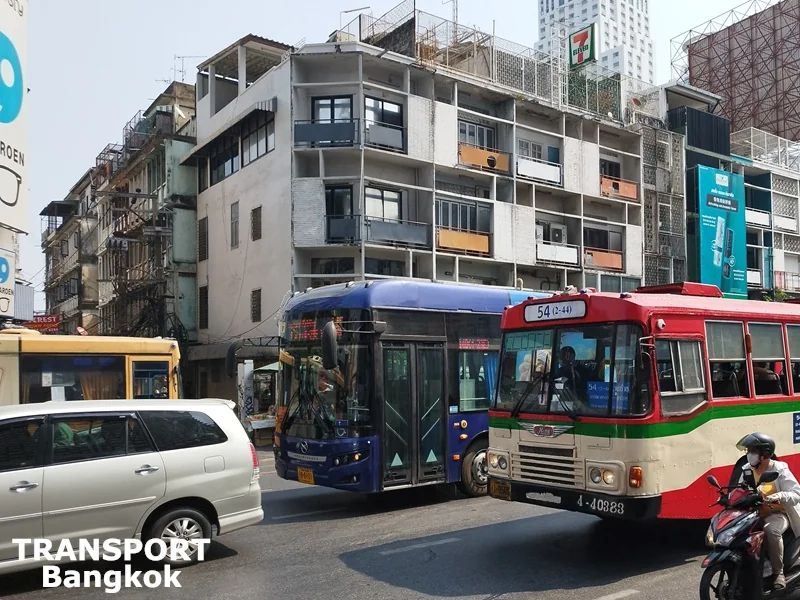
As Bangkok city is huge and there are many public bus routes connecting different corners of the metropolis, you will not find a unified Bangkok bus map with all the routes laid out on one sheet of paper. However, you can find a way to travel to your destination in Bangkok by public bus by using one of the apps with a Bangkok bus map or relying on the official bus route maps.
Bangkok Bus Service Providers
Public bus services in Bangkok are operated by the governmental Bangkok Mass Transit Authority (BMTA) and private operator Thai Smile Group (also called Thai Smile Bus), which was established in 2020 and jointly invested with 8 original private bus companies with licenses to operate public transport routes.
If you prefer a more tourist-friendly way of exploring main Bangkok attractions by bus, you can choose one of the Bangkok hop-on hop-off bus services. Simply book online a Bangkok Hop-On Hop-Off Bus Ticket and see the most famous attractions in the city at your own pace for 24, 48, or 72 hours.
Bangkok Bus Map Options
As Bangkok city is huge and there are many public bus routes connecting different corners of the metropolis, you will not find a unified Bangkok bus map with all the routes laid out on one sheet of paper.
However, to find your way to travel from your location to the desired destination by public bus, you can use one of the applications with a Bangkok bus map, check the official bus route map provided by the bus operator, or rely on the route map found at the bus stop (if you will be lucky enough to find one).
Official Bangkok Bus Route Maps
Both main public bus service operators in Bangkok have their own websites, where the routes operated by their companies are presented. Every bus route listing on the websites of BMTA and Thai Smile Bus displays the route map that should be considered as the official bus route map. However, the information there is provided in Thai only, so it might not be suitable for most foreign travelers.
The list of Bangkok bus routes operated by BMTA with interactive route maps created on Google Maps can be found here: BMTA Routes.
Bangkok bus routes operated by Thai Smile Group with printed route maps can be found here: Thai Smile Bus Routes.
Bangkok Bus Map on Google Maps App
The easiest way to find a required Bangkok bus route for your journey is using the Google Maps app, as it works quite well with the Bangkok public transport system. Just search for your desired destination, click “Directions,” choose public transport, and the best route will be presented to you. If the only type of public transport you would like to use is a public bus, just click “Options” and choose “Bus” as your preferred mode.

However, don’t rely on the schedule and the length of the proposed journey presented on the app. Traffic is unpredictable in Bangkok, and your waiting time and journey time might vary significantly depending on the traffic.
Bangkok Bus Map on ViaBus App
ViaBus is one of Thailand's apps that is a must-have for public bus riders. The app is very useful when traveling by Bangkok bus, as with the use of it, you no longer have to stand and wait for the bus without knowing when it will come. The new buses are equipped with GPS, so you can check the current location of each bus, bus route, and bus stop. However, the app works the best with BMTA bus routes, as it doesn't seem to get real-time GPS data from the bus routes operated by Thai Smile Bus.
The Bangkok bus map on ViaBus is especially useful if you are looking to combine traveling by public bus with songthaews, as this app displays songthaew routes as well.
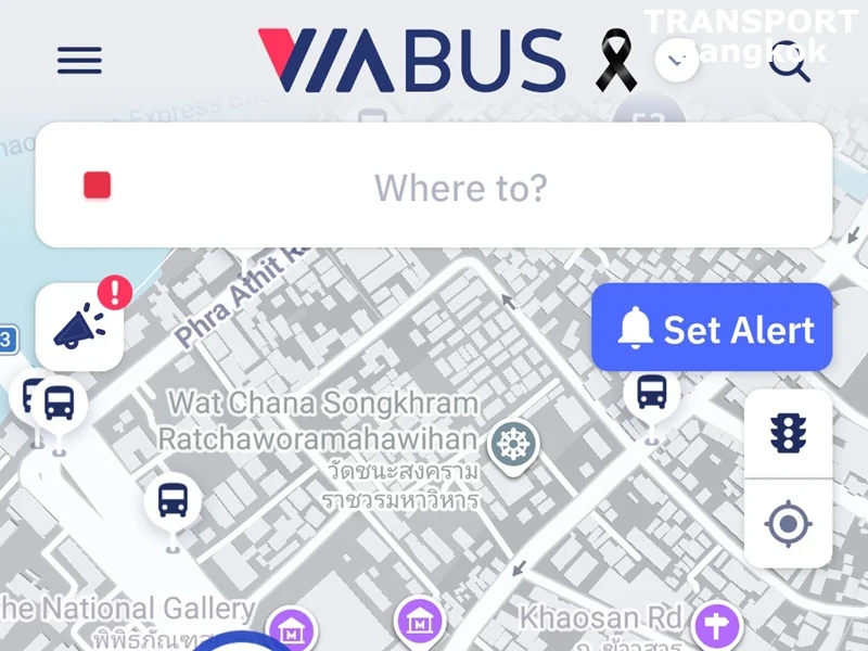
On this Bangkok Bus Map application, you can:
- Explore bus stops nearby and track buses passing you in real-time.
- See bus routes passing by, check each route's GPS status, and get other details of the route.
- Get transit directions from A to B, or search bus stops.
Bangkok Bus Map on TSB Go Plus App
If you are only interested in using the electric buses of Thai Smile Bus, then their own app called TSB Go Plus could be the best choice for a Bangkok bus map. The app displays all bus routes of the company and displays GPS data from all their buses. The app also lets you:
- Find stops and lines, see stops near you, track buses, and get notified when they arrive for free!!
- Get a recommended route to your destination
- View the history of the last 15 Hop Card transactions.
- Top up and update your Hop Card balance
- Accumulate carbon credits from your travels with the Hop Card and redeem them for rewards.
If you will be using the electric bus and boat service several times a day, get Thai Go Day Pass that covers all Thai Smile Bus routes as well as Thai Smile Boat routes. The pass can later be redeemed and used on the TSB Go Plus application.
Bangkok Bus Route Map at Bus Stop
You can also see a Bangkok bus map for a specific route on the display board at some of the bus stops. However, consider yourself lucky if you find it.
The names of the roads passed by the bus route are written on the colorful scale, and the most famous landmarks are noted nearby. There are separate scales for both directions, as the bus route can differ a bit depending on the direction.
Bus Stops in Bangkok
There are thousands of bus stops all around Bangkok. However, finding one sometimes can be a challenge, as it’s not uncommon for the bus stop signs to be covered by other objects. Look for a bus stop sign like this.

There are also shelters at some of the bus stops. These are much more difficult to miss.
Bangkok bus routes passing the bus stop are normally written on the bus stop sign, but it won’t necessarily be like that, as the sign can be covered with graffiti or stickers.

If the bus stop has a shelter, your chances of seeing the list of bus routes passing by are much higher. But it still can be incomplete or outdated.
If you can’t find the list of bus routes at the bus stop, just stay there for a while and watch buses passing by – you will get an idea about your options at that particular bus stop soon. Otherwise, use an app such as ViaBus, TSB Go Plus, or Google Maps.
Bangkok Hop-on Hop-off Bus Route Map
The Bangkok Hop-On Hop-Off bus route passes by Siam Paragon, MBK Center, Chinatown, Khao San Road, Wat Suthat, the Giant Swing, Wat Pho, the Grand Palace, Wat Arun, ICONSIAM, King Power MahaNakhon, and Patpong Night Market.
